
Land reclamation is the process of restoring, improving, or converting land for productive use, often in areas that have been degraded, submerged, or rendered unsuitable for development. This practice is essential in industries such as coastal development, agriculture, urban expansion, and mining land reclamation, where repurposing land can support economic growth, environmental restoration, and sustainable land use.
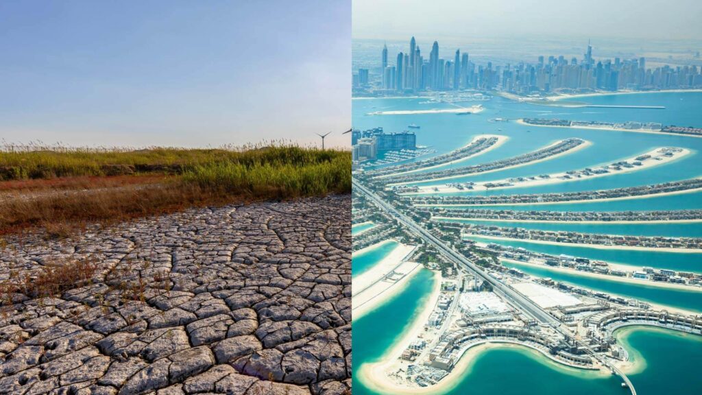
In coastal development, land reclamation expands shorelines, creates artificial islands, and protects against erosion and rising sea levels. In agriculture, it restores degraded soils, enhances food production, and combats desertification. Urban expansion relies on land reclamation to accommodate growing populations by transforming wetlands, marshlands, and previously unusable terrain into habitable spaces. Similarly, mining land reclamation focuses on rehabilitating disturbed landscapes, restoring ecosystems, and ensuring compliance with environmental regulations after resource extraction.
Despite its benefits, land reclamation has traditionally faced several challenges:
- Environmental Impact: If not properly managed, reclamation projects can disrupt natural ecosystems, lead to habitat loss, and contribute to soil degradation.
- High Costs and Resource Intensity: Conventional land reclamation requires extensive excavation, dredging, and soil replacement, making it expensive and labor-intensive.
- Regulatory Compliance: Strict environmental laws and sustainability requirements demand precise planning and monitoring to mitigate adverse effects.
- Uncertainty in Land Stability: Determining soil quality, water levels, and structural integrity is complex, often leading to unforeseen complications during and after reclamation.
To overcome these challenges, modern land reclamation projects are increasingly leveraging Geographic Information Systems (GIS) and satellite imaging to enhance efficiency and sustainability. GIS enables data-driven decision-making by providing detailed maps, spatial analysis, and predictive modeling for land restoration. It helps planners assess terrain suitability, track changes in land use, and optimize reclamation strategies.
Meanwhile, satellite imaging offers real-time, high-resolution data on land conditions, allowing for continuous monitoring of reclamation progress. It provides insights into vegetation recovery, erosion control, and water resource management, ensuring that mining land reclamation and other projects meet environmental and regulatory standards. By integrating these technologies, land reclamation efforts become more precise, cost-effective, and environmentally responsible.
Understanding Land Reclamation and Its Applications
What is Land Reclamation?
Land reclamation is the process of converting damaged, degraded, or submerged land into usable land for agriculture, infrastructure, or environmental restoration. Its primary objectives include restoring ecosystems, improving soil stability, expanding habitable areas, and mitigating the effects of land degradation caused by natural or human activities.
Land reclamation’s meaning varies depending on the industry and purpose. In some cases, it involves restoring coastal land by preventing erosion and creating new shorelines. In other instances, it focuses on converting former industrial or mining sites into productive landscapes, ensuring long-term environmental sustainability.
Industries That Benefit from Land Reclamation
Several industries rely on land reclamation to expand their operational footprint, restore natural resources, and optimize land use:
- Coastal Development: Many coastal cities use land reclamation to combat rising sea levels, prevent shoreline erosion, and create additional space for infrastructure and tourism. Techniques such as dredging and sandfilling help expand coastlines and construct artificial islands.
- Agriculture: Land reclamation plays a crucial role in restoring degraded soils, transforming arid regions into fertile farmland, and improving irrigation systems. This process helps address food security challenges in areas with limited arable land.
- Urban Expansion: As urbanization increases, cities are reclaiming land from wetlands, floodplains, and former industrial sites to accommodate growing populations, develop housing, and expand infrastructure.
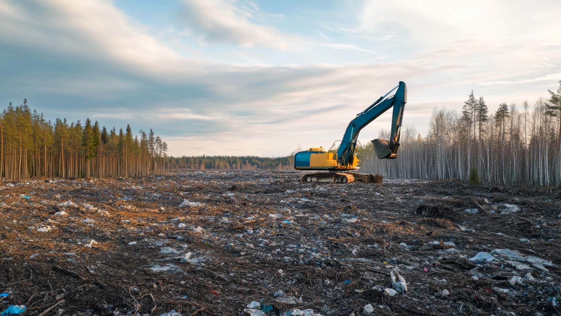
- Mining Land Reclamation: One of the most critical applications of land reclamation is in the mining industry, where companies must rehabilitate land after resource extraction. This process involves restoring vegetation, stabilizing soil, and ensuring compliance with environmental regulations to reduce long-term ecological damage.
Challenges in Land Reclamation Projects
Despite its benefits, land reclamation presents several challenges that must be addressed for successful project execution:
- Environmental Concerns: Reclamation projects can disrupt ecosystems, leading to habitat loss, soil degradation, and sedimentation. If not managed properly, they may negatively impact water quality, biodiversity, and local wildlife.
- Engineering Challenges: Advanced engineering techniques are required to ensure soil stability, proper drainage, and the long-term sustainability of reclaimed land. Issues such as subsidence, fluctuations in the water table, and erosion control can complicate reclamation efforts.
- High Costs and Regulatory Compliance: Land reclamation projects are expensive, requiring significant investments in planning, excavation, and environmental monitoring. Additionally, strict environmental regulations demand careful compliance to prevent legal and financial repercussions.
By addressing these challenges through technological advancements, including GIS and satellite imaging, land reclamation can be made more efficient, cost-effective, and environmentally responsible.
The Role of GIS in Land Reclamation Planning
GIS and Its Capabilities in Land Reclamation
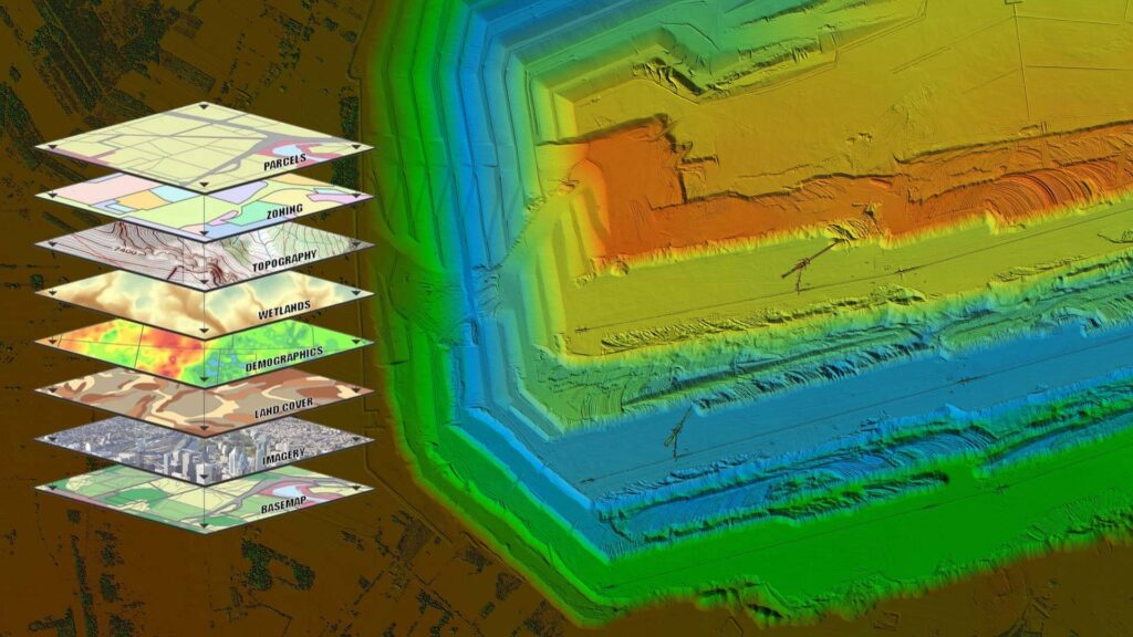
Geographic Information Systems (GIS) have revolutionized the planning and execution of land reclamation projects. By integrating spatial data, GIS enhances decision-making processes, allowing engineers, environmentalists, and project managers to analyze land conditions precisely.
One of the primary benefits of GIS in land reclamation is its ability to collect, store, and interpret complex geographical data. This enables project planners to:
- Conduct Data Collection and Spatial Analysis: GIS compiles data from various sources, including satellite imagery, remote sensors, and ground surveys. This information is crucial for assessing soil composition, hydrology, and environmental conditions before beginning a reclamation project.
- Map Soil Conditions, Water Resources, and Topography: By visualizing critical land features, GIS helps identify areas prone to erosion, waterlogging, or instability. This ensures that soil enhancement and water management strategies are effectively implemented.
- Identify Optimal Sites for Land Reclamation Projects: GIS overlays multiple data layers—such as land use history, vegetation cover, and infrastructure proximity—to determine the most suitable locations for mining land reclamation, urban development, and coastal expansion.
How GIS Enhances Project Efficiency
The ability to analyze and interpret spatial data in real time makes GIS an invaluable tool for improving efficiency in land reclamation projects. By leveraging GIS technology, project managers can:
- Predict Environmental Impacts and Mitigate Risks: GIS models simulate how land reclamation activities might affect the surrounding environment. For instance, in mining land reclamation, GIS can predict how restored landscapes will interact with local water systems and ecosystems, ensuring sustainability.
- Monitor Land Use Changes Over Time: GIS helps assess vegetation growth, soil stabilization, and water retention by continuously tracking reclamation progress. This long-term monitoring is essential for confirming that reclaimed land remains viable for its intended use.
- Improve Communication Between Stakeholders with Visualized Data: GIS mapping tools present complex information in an easy-to-understand format, facilitating collaboration between engineers, environmental agencies, and regulatory bodies. These visual representations help stakeholders make informed decisions and comply with legal requirements.
Integrating GIS into land reclamation planning makes projects more efficient, cost-effective, and environmentally sustainable. Analyzing and predicting land changes before implementation significantly reduces risks and enhances long-term project success.
The Impact of Satellite Imaging on Land Reclamation

How Satellite Imaging Supports Project Planning
Satellite imaging has become a game-changer in land reclamation, providing accurate, real-time data to enhance project planning and execution. By leveraging advanced satellite technology, reclamation specialists can monitor and analyze land conditions remotely, improving decision-making and ensuring project success.
- Real-Time Monitoring of Reclamation Progress: Satellite imaging allows continuous tracking of reclamation activities, ensuring that each phase aligns with planned objectives. This is particularly beneficial for large-scale projects, where ground inspections alone are insufficient to capture detailed progress.
- High-Resolution Imaging for Precise Land Assessment: Modern satellite imagery offers high-definition visuals of terrain, water bodies, and vegetation. This helps project managers identify potential risks and assess land stability before and during reclamation, ensuring that every stage of the process is optimized for maximum efficiency.
- Remote Sensing Technology for Tracking Vegetation Recovery: Ecosystem restoration is a critical aspect of successful land reclamation. Satellite-based remote sensing allows for detailed monitoring of vegetation regrowth, soil moisture levels, and overall land rehabilitation, ensuring long-term sustainability.
Advantages of Satellite Imaging in Mining Land Reclamation
For mining land reclamation, satellite imaging provides essential data that aids in rehabilitation efforts after resource extraction. Mining sites often undergo significant land degradation, making accurate monitoring and planning critical for effective restoration.
- Assessing the Extent of Land Degradation: Satellite imagery analyzes soil composition, water levels, and terrain alterations to help determine the impact of mining activities. This data enables reclamation teams to develop targeted restoration plans.
- Ensuring Compliance with Environmental Regulations: Government agencies and environmental organizations use satellite data to monitor reclamation projects and ensure compliance with regulations. This prevents illegal land use and promotes responsible land management.
- Enhancing Restoration Efforts Through Data-Driven Insights: Continuous updates from satellite imagery allow reclamation teams to make informed decisions about soil treatment, water drainage improvements, and reforestation efforts. The ability to adjust strategies in real time leads to more efficient and sustainable land restoration.
By integrating satellite imaging into land reclamation planning, project managers can enhance precision, improve environmental outcomes, and ensure compliance with regulatory standards. The combination of remote sensing and GIS technology provides a powerful toolkit for modern reclamation efforts.
Combining GIS and Satellite Imaging for Optimal Land Reclamation
Integration of GIS and Satellite Imaging for Comprehensive Analysis
The combination of GIS (Geographic Information Systems) and satellite imaging has revolutionized the way land reclamation projects are planned and executed. By integrating spatial data from satellites with GIS mapping tools, project managers gain a deeper understanding of terrain conditions, environmental risks, and optimal restoration strategies.
- Using Satellite Data for GIS Mapping and Planning: High-resolution satellite imagery feeds directly into GIS platforms, allowing for accurate mapping of soil conditions, water resources, and topographical changes. This integration provides a detailed view of land suitability, helping to determine the best reclamation approaches.
- Enhancing Predictive Models for Land Stability and Environmental Restoration: GIS uses satellite-derived data to create predictive models that assess land stability, erosion risks, and vegetation regrowth potential. This helps engineers design more effective reclamation strategies, particularly in mining land reclamation, where land degradation is extensive.
Reclamation teams can develop data-driven plans that minimize risks and maximize land restoration success by combining GIS and satellite imaging.
Improving Decision-Making in Land Reclamation Projects
The integration of GIS and satellite imaging enhances land analysis and improves real-time decision-making throughout the reclamation process.

- Real-Time Tracking of Project Milestones: Continuous satellite monitoring and GIS-based progress tracking allow project managers to oversee land reclamation efforts remotely and ensure that all milestones are met on schedule. This is particularly beneficial for large-scale mining land reclamation projects, where field inspections alone may be insufficient.
- Minimizing Costs and Optimizing Resource Allocation: By using GIS and satellite data, reclamation teams can allocate resources more efficiently, reducing unnecessary expenses. Accurate data ensures that land preparation, soil treatment, and vegetation restoration efforts are targeted precisely where they are needed.
- Strengthening Regulatory Compliance and Reporting: Many land reclamation projects must comply with strict environmental regulations. GIS and satellite imaging provide detailed records of land use changes, reclamation progress, and ecological recovery, making it easier to generate compliance reports and meet legal requirements.
By leveraging GIS and satellite imaging in land reclamation, project managers can restore degraded land with greater precision, efficiency, and sustainability. This powerful combination ensures that reclamation efforts are not only effective but also environmentally responsible and cost-efficient.
Future of Technological Advancements in Land Reclamation

Emerging Technologies in Land Reclamation
As land reclamation continues to evolve, emerging technologies are enhancing efficiency, accuracy, and sustainability in restoration efforts. Innovations in artificial intelligence, drone technology, and digital modeling are transforming how land is rehabilitated and monitored.
- AI and Machine Learning for Predictive Analysis: Artificial intelligence (AI) and machine learning algorithms analyze vast datasets to predict land stability, erosion risks, and vegetation growth patterns. These predictive models improve decision-making in mining land reclamation, helping engineers design more effective restoration strategies and mitigate environmental risks.
- Drone Technology for Site Surveys and Monitoring: Drones equipped with advanced sensors and cameras provide high-resolution aerial imagery for surveying reclaimed sites. These UAVs (unmanned aerial vehicles) allow real-time monitoring of soil conditions, water drainage, and vegetation growth, reducing the need for costly on-site inspections.
- 3D Modeling and Digital Twins for Enhanced Project Visualization: Digital twin technology creates virtual replicas of land reclamation sites, enabling project planners to simulate different restoration scenarios before implementing changes. By integrating GIS and satellite data, these 3D models provide a comprehensive view of land conditions, improving project accuracy and efficiency.
The Evolving Role of GIS and Satellite Imaging
As technology advances, GIS and satellite imaging continue to play a vital role in optimizing land reclamation projects. New developments in imaging and data accessibility are making reclamation efforts more precise and environmentally sustainable.
- Advancements in Hyperspectral Imaging: Unlike traditional satellite imagery, hyperspectral imaging captures a broader range of wavelengths, providing detailed information on soil composition, vegetation health, and water quality. This technology is particularly useful in mining land reclamation, where understanding land degradation and soil recovery is essential.
- Increased Accessibility to GIS Tools for Project Planners: Cloud-based GIS platforms and user-friendly interfaces are making spatial analysis tools more accessible to project managers, engineers, and environmental consultants. This democratization of GIS technology enables more efficient planning and execution of land reclamation projects.
- Improved Environmental Sustainability Through Data-Driven Reclamation Strategies: The integration of AI, GIS, and satellite imaging allows for data-driven approaches to land reclamation, reducing waste, optimizing resource use, and minimizing ecological disruption. By leveraging these advanced technologies, reclamation projects can be more sustainable while ensuring long-term land productivity.
With continuous advancements in technology, land reclamation is becoming more efficient, cost-effective, and environmentally responsible. As these innovations progress, the ability to restore and repurpose land for various industries, including mining land reclamation, will continue to improve.
Conclusion
The integration of advanced technologies such as GIS, satellite imaging, AI, and drone technology has significantly improved the efficiency and sustainability of land reclamation projects. These innovations allow for precise data collection, real-time monitoring, and predictive analysis, enabling project planners to make informed decisions while minimizing environmental impact. Whether reclaiming land for coastal development, agriculture, urban expansion, or mining land reclamation, the ability to assess terrain stability, track reclamation progress, and ensure regulatory compliance has never been more accessible. By leveraging these tools, industries can optimize resource allocation, reduce costs, and enhance the long-term success of their land restoration efforts.
As technology continues to evolve, the future of land reclamation will see even greater advancements in automation, remote sensing, and environmental modeling. The development of hyperspectral imaging, AI-driven analytics, and digital twin simulations will further refine reclamation strategies, ensuring that restored land remains viable and productive for years to come. By embracing these technological innovations, industries can transform degraded landscapes into thriving ecosystems, reinforcing the importance of sustainable land management in a rapidly developing world.